Reading the Weather:
Most countries, including those have a climate; the United Kingdom is unique in that we have several different weather patterns, with a broad ranging set of seasons. Weather, and the understanding of it is often deemed to be a difficult subject to understand, but hopefully this page will start to demystify the art of interpreting weather and it's forecasts. Some good weather forecasting sites include:
The Weather Basics:
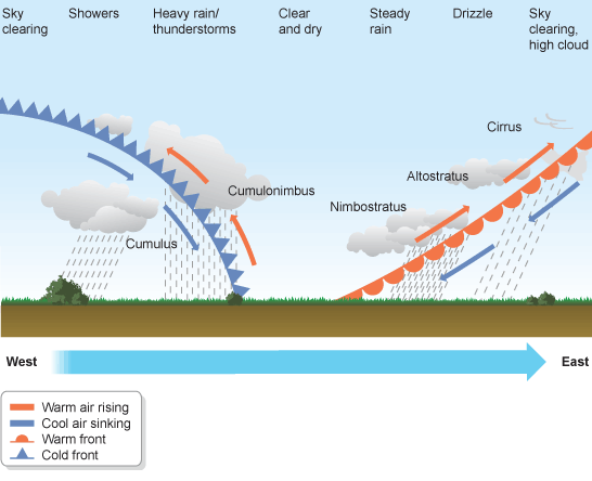
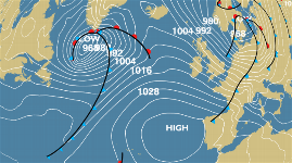
A front is a physical boundary separating two masses of air of different densities and is the principal cause of weather. In forecasting, fronts are depicted using various coloured lines and symbols depending on the type of front.; the three basic fronts are warm, cold and occluded. The air masses separated by a front usually differ in temperature and humidity, thus, cold fronts may feature narrow bands of thunderstorms and severe weather, and may on occasion be preceded by squall lines or dry lines. Warm fronts are usually preceded by stratiform precipitation and fog. The weather usually clears quickly after a front's passage, with some fronts passing in as little as 4 hours. Some fronts produce no precipitation and little cloudiness, although there is invariably a wind shift. In elementary forecasting, it should be remembered that cold fronts always follow warm fronts, see below:
The BBC do a Bitsize Lesson on Weather in their Geography GCSE revision pages, and this section is a good place to start if you want to understand weather in a bit more detail before moving on to more intricate weather analysis.
Fronts are generally guided by winds, but do not generally move as quickly. Cold fronts and occluded fronts in the Northern Hemisphere usually travel from the north west to south east, while warm fronts move more poleward with time. In the Northern Hemisphere a warm front moves from south west to north east. Movement is largely caused by the pressure gradient force (horizontal differences in atmospheric pressure) and the Coriolis effect, which is caused by Earth's spinning about its axis. Frontal zones can be slowed down by geographic features like mountains and large bodies of warm water, see below:
![]() A Warm Front: The leading edge of an advancing warmer air mass, the passage of which commonly brings cloud and precipitation followed by increasing temperature and/or humidity.
A Warm Front: The leading edge of an advancing warmer air mass, the passage of which commonly brings cloud and precipitation followed by increasing temperature and/or humidity.
![]() A Cold Front: The leading edge of an advancing colder air mass. Its passage is usually marked by cloud and precipitation, followed by a drop in temperature and/or humidity. The leading edge of an advancing colder air mass. Its passage is usually marked by cloud and precipitation, followed by a drop in temperature and/or humidity.
A Cold Front: The leading edge of an advancing colder air mass. Its passage is usually marked by cloud and precipitation, followed by a drop in temperature and/or humidity. The leading edge of an advancing colder air mass. Its passage is usually marked by cloud and precipitation, followed by a drop in temperature and/or humidity.
![]() An Occluded Front: Occlusions form when the cold front of a depression catches up with the warm front, lifting the warm air between the fronts into a narrow wedge above the surface. Occluded fronts bring cloud and precipitation. Occlusions form when the cold front of a depression catches up with the warm front, lifting the warm air between the fronts into a narrow wedge above the surface. Occluded fronts bring cloud and precipitation.
An Occluded Front: Occlusions form when the cold front of a depression catches up with the warm front, lifting the warm air between the fronts into a narrow wedge above the surface. Occluded fronts bring cloud and precipitation. Occlusions form when the cold front of a depression catches up with the warm front, lifting the warm air between the fronts into a narrow wedge above the surface. Occluded fronts bring cloud and precipitation.
Basic Cloud Formations:
A cloud is a visible mass of liquid droplets or frozen crystals made of water suspended in the atmosphere above the surface of a planetary body. Two processes can lead to air becoming saturated: cooling the air or adding water vaporu to the air. In general, precipitation will fall to the surface. Clouds can show convective development like cumulus, appear in layered sheets such as stratus, or take the form of thin fibrous wisps, as in the case of cirrus.
Prefixes are used in connection with clouds: strato for low cumuliform-category clouds that show some stratiform characteristics, nimbo for thick stratiform clouds that can produce moderate to heavy precipitation, alto for middle clouds, and cirro for high clouds. The following five, basic, clouds form the main volume of both warm and cold fronts as shown above.
 |  |  |  |  |
| Ci | As | Ns | Cb | Cu |
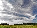
Ringlet or Curtain Clouds. >5,000msl. White and grey clouds forming before weather systems that indicate the arrival of precipitation, normally within 4-6 hours. Cirrus clouds precipitate small ice crystals that evaporate before they reach ground level.
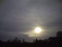
[As] Altostratus:
Alto- (Middle) - stratus (layered) clouds. 2,400-6,100msl. Generally forms a sheet or layered appearance and the sun can normally be seen through it. Rain is possible in thickening clouds and form nimbostratus clouds if rain becomes persistent or significant.
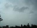
[Ns] Nimbostratus:
Rain, layered cloud. Below 3,000msl. Forms a dark, widespread, formless layer leading to significant rain fall.
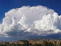
[Cb] Cumulonimbus:
Severe Rain cloud. 2,000-16,000msl. Very
tall and large clouds involved in thunder storms and most inclement
weather and is a result of atmospheric instability. Ranging from white
to dark grey in colour.
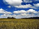
[Cu] Cumulus:
Heap Cloud. Normally below 2,000msl. White, with a 'puffy' or cotton appearance. Sometimes causing limited precipitation.
8 Basic Questions to Ask When Interpreting Weather Forecasts:
1. How wordy is the forecast paragraph?
"Bright to start, clouding over later." | "A bright and chilly start for most areas except Northern Ireland, where it will be cloudier. Then becoming cloudy in all areas through the day, with rain in western areas later, becoming heavy in western Scotland. Winds becoming stronger later". |
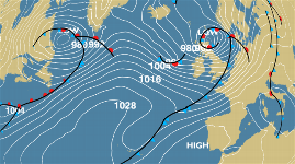
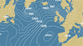
3. Is the forecast under the influence of high or low pressure (HP/LP)?
4. Is their a [significant] weather front?
5. How close are the isobars on the synoptic chart?
6. Where is the wind coming from?
7. Does the wind come from land or sea?
8. Does the forecast match what is outside the window?